- the phenomenal mid-August thunderstorms
BACK TO WEATHER-BLOG MENU
The Welsh Weather & Dyfi Valley landscapes Image-Library - Click HERE
This post is about the extraordinary 3-day thunderfest that took place here in the Dyfi Valley on August 10th-12th. I've not seen anything so intense for many years. The synoptic situation was high pressure over Norway, a thundery low over northern France bristling with troughs, a long cold front running N-S off western Ireland and a fairly slack airflow over the UK. Forecast instability and CAPE were huge and some potent pockets of favourable wind-shear were present on all three days ensuring the possibility of severe weather. By Wednesday 12th, storm-tops were reaching up to 43,000 feet above sea level - that's more than 8 miles high!
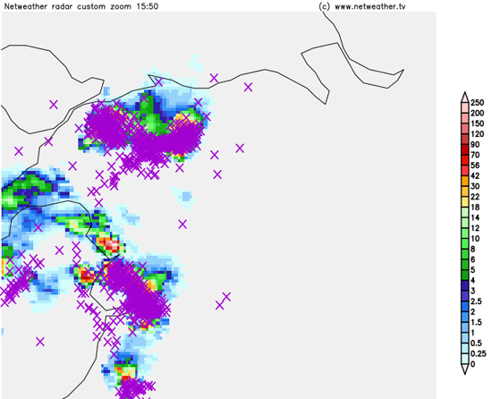
Although there was activity early on Monday 10th August with a late-morning storm over Cardigan Bay, the real fun began that afternoon as the radar shows:
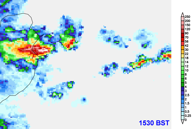
That very heavy core centre left is only a mile to my north. But the real treat was still to come after dark that evening. An incredibly active electrical storm passed to my east and gave a display of strobelike intensity. I just stood out in the back field and gawped at the spectacle for about an hour.
Howard Kirby got some of the display on camera in Carno, on the road to Newtown. Here's a link to his video:
https://www.youtube.com/watch?v=NsmdPylasgk&feature=youtu.be
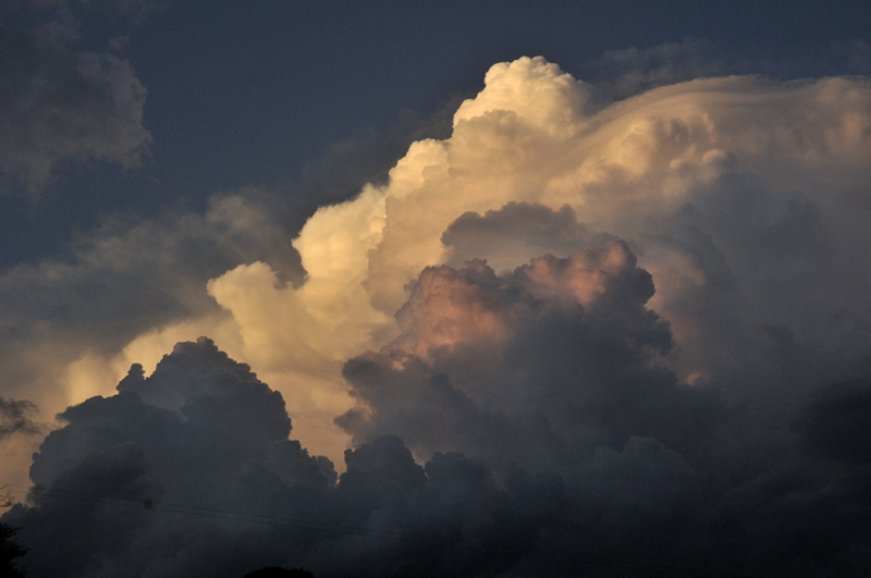
The next day, Tuesday 11th, was a photo-fest, an absolute visual feast. On this occasion, favourable wind-shear properties for supercells were evident in forecast models and sure enough, a storm to my south split into two in the early evening. The right-hand one collapsed but the left-hand one started to intensify and move a little to the left of the steering-flow. Visibility in the valley early to mid evening was lousy, with fog having worked up from the sea, so when I went to the back field to take a look I was stunned by what I saw:
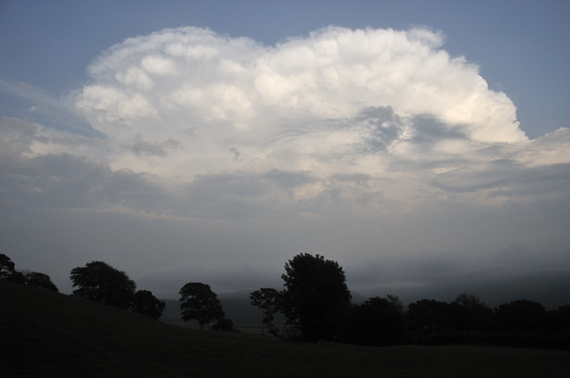
Again, a very high cloud-top. Soon, thunder became audible as the storm approached the Machynlleth district. Another shot, slightly under-exposed - too good a storm not to take a few!
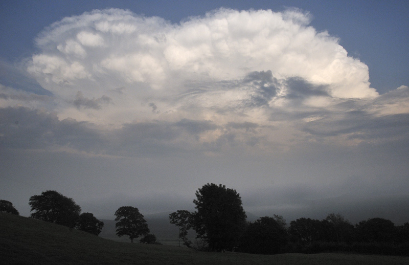
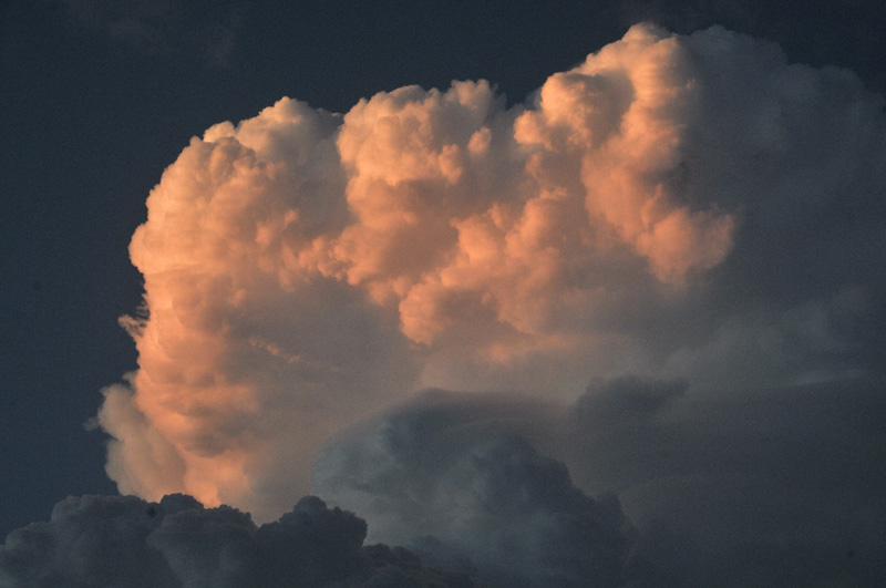
This was its closest approach with sunset closing in. Lightning was near-constant, all intracloud and making the whole cloud-top light up at times. The updraught towers in this next image were shooting upwards - some of the fastest I have ever seen:
Just a little later in this immense, boiling cloud-bank. Towers to the left have started to glaciate - to form anvils.
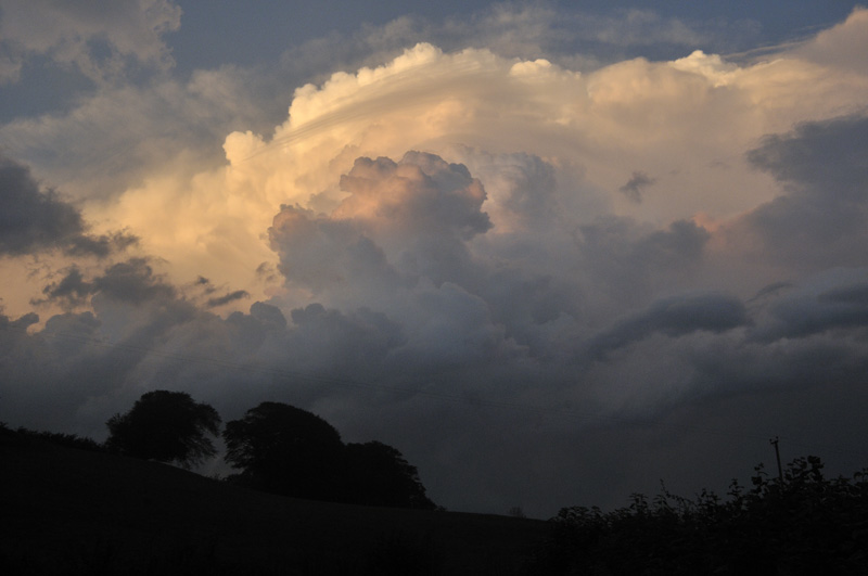
People under the storm, further up the Dyfi Valley, were being pelted with hailstones to 20 mm at this time.
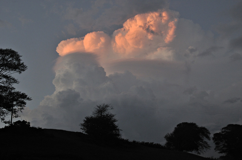
A final one with an Alpenglow on the updraught-tops. The thing was still crackling with intracloud lightning.
Wednesday 12th saw yet another very intense storm cross the Dyfi Valley. This one was an audio, rather than a visual experience, since it came a lot closer: 70 mm of rain fell in Pennal in half an hour. A friend had to pull in because the visibility became so bad and he placed a bucket outside his car to see what amount of rainwater he could catch - crude but effective!
I've tried to think of ways to describe the thunder. Although overhead, it was coming mainly from the upper parts of the cloud so the lightning was several miles above me. I thought about a cement-mixer full of an assortment of gravel and brickbats but it dawned on me all of a sudden where I'd heard a similar sound. In that famous film Chasing Ice, the bit from the Petersen Glacier in Greenland, where a huge calving event occurs. For over an hour the thunder was absolutely continuous - it was relentless! The only interruption was a C-G strike with, a second or two later, a gunshot blast of sound. I didn't see what it hit due to a building being in the way but it was very close.
This storm tracked northwards towards Talyllyn, where a friend, Brian Mathews, runs the Pen-y-bont Hotel. He managed to get a sound recording of the thunder which I've uploaded to Soundcloud if you want a listen. All the rumbling is thunder: there was very little wind with this storm: Now imagine a whole hour of that!
Here's the radar plot of this storm at peak, centre-left. Again, the core is at >200 mm/hour. There was hail in the storm too - stones, of a very irregular shape and up to 15 mm across, were hitting the ground here, in a sporadic fashion throughout.
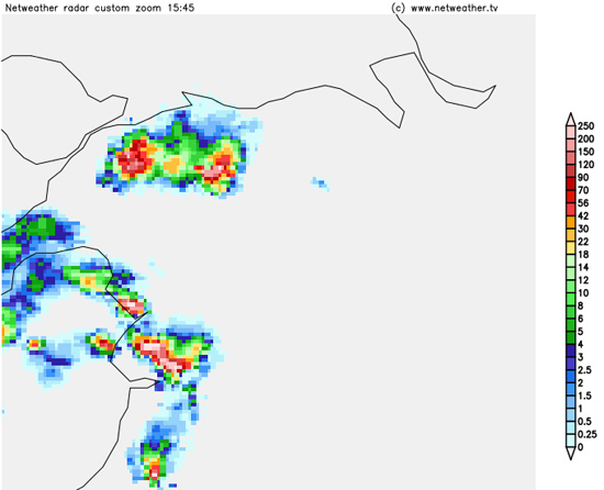
Now just look at the sferics (lightning) plot!!
Since then, conditions have been unsettled rather a lot of the time, with one particularly intense Atlantic storm on August 20th and another five days later. The latter was brutal. I co-manage a facebook group for local travel alerts and at one point of the afternoon of the 25th, reports were being posted almost on a minute-by-minute basis: virtually every road in and out of Machynlleth was blocked by fallen trees.
More soon.
The Welsh Weather & Dyfi Valley landscapes Image-Library - Click HERE
BACK TO WEATHER-BLOG MENU