BACK TO WEATHER-BLOG MENU
The Welsh Weather & Dyfi Valley landscapes Image-Library - Click HERE
Regulars will have noticed a lack of
recent updates to my weather-blog: however I have been
far from idle. The weather of 2021 was rather ordinary,
2022 likewise (so far) and as I have said before, the
emphasis from now on with this blog will be on
exceptionally interesting events, which means there will
be some years with little or nothing, others with
several pages.......
So I wrote just over 2 months age and
just like buses, two notable weather events occurred
within 48 hours in the Dyfi Valley!
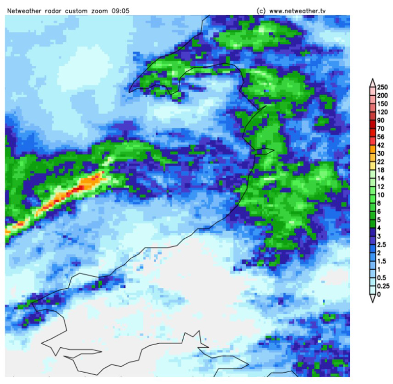
Wednesday April 6th dawned unremarkably but I knew an
unstable airflow was in place and shortly after 0900 an
ominous feature was visible on the radar (below, L):
I put out a heads-up on facebook because the line looked to be interesting and would affect us in the Dyfi Valley. Here's the radar sequence 0930-1000: the system was heading our way at approximately 40 mph.
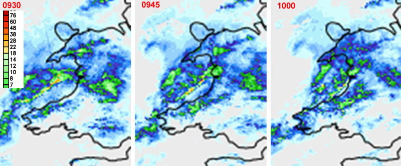
Although the line appears to be losing strength, it is also maturing and bowing out in places - this happens when parts of the line surge forward relative to others. Even stronger winds occur as a consequence, around such "bowing segments". Another thing that can complicate matters is if waves run along the line: it will tend to break up into a series of areas of strong rainfall separated by areas with little rainfall, forming what we call a line-echo wave pattern. Such features are associated with major turbulence, wind shear and high vorticity - the tendency for some of the air to be rotating.
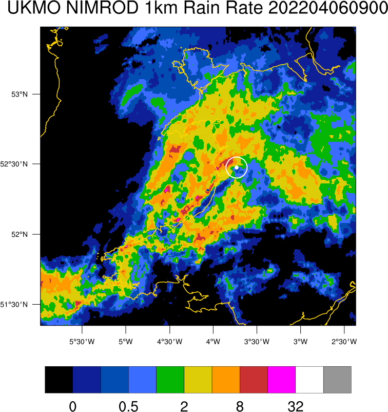
Here's the radar for 0900 UTC (1000 BST). The bullseye is Machynlleth. Image credit: David Smart, UCL Hazard Centre. Original data: UKMO via CEDA. UK Open Government Licence V2.
In the radar image, the squall-line is visible close to and sub-parallel to the coast SW of Machynlleth (reds/pinks are the heaviest rain). To the north-west of Machynlleth is another area of heavy rain, over the hills north of the Dyfi estuary. Note the bowing sections on the squall-line and the narrow break in heavier precipitation west of Machynlleth. This break is close to the Dyfi Estuary and is potentially significant.
Reports of torrential rain started coming in as this system made landfall along the Cardigan Bay coast and then it reached Cwrt a bit after 1000 BST. High winds, poor visibility and rain getting atomised off surfaces - all usual squall-line stuff. At Borth Lifeboat Station, winds increased from 15 to 45 knots (thanks to Shem Llewellyn for this info) and at the Dyfi Osprey Project, one of the ospreys got blown off its nest. But only a mile away from me, at Gogarth Hall farm, it turned out something a lot more serious had happened.
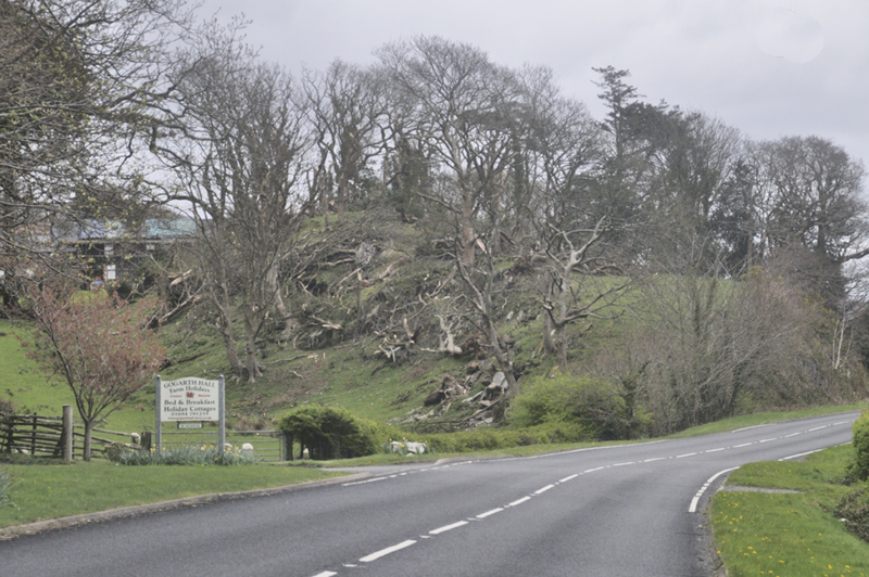
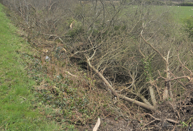
The next day was dryer and I went over to the spot where a tornado had been reported. This was the sight that greeted me:
Being the Site Investigation Coordinator for TORRO for this part of Wales is a voluntary position that I have held for many years. Site investigation involves mapping reported tornado tracks and carefully documenting the types of damage done. Through such forensic studies, it can firstly be established whether or not the cause was in fact a tornado and secondly, if so, how strong the tornado was. Tornadoes have long been ranked in this manner, beginning in 1971 in the USA. Since tornadoes are uncommon in Wales, the position is not that time-consuming - except when something like this happens. I parked up and got to work. First thing was to determine the extent of the track and that could likely be done by walking along the main road's grass verges, since the damage-path ran in parallel to it, by and large.
The start of its track was evidently near the base of a steep hillside:
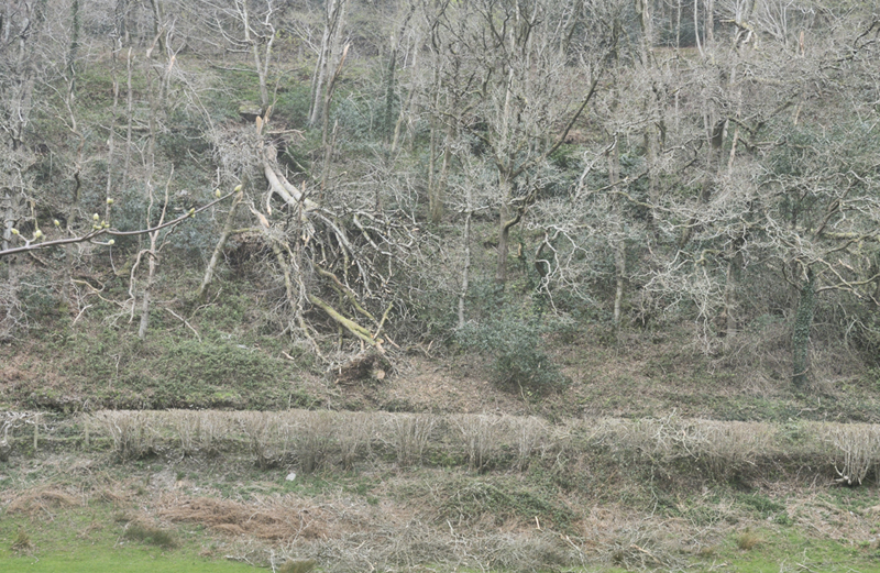
Here, over around a hundred metres across its path, a number of trees had been brought down by the tornado, blocking the road up to the farm (in the photo they have been cut up to reallow road access). Continuing along the main road, I had several side-views of the damage-track:
This was clearly a powerful tornado - I knew it was a tornado through experience but would later confirm that through detailed scientific observation.
You could actually see where the tornado crossed the main A493 road; this is damage to the line of trees on its other (southern) side:
Beyond here the tornado seemes to have petered out quickly: small debris was scattered in the pastures but no heavy stuff, whereas the remains of the hedge were also full of lofted tree-branches that had crossed the road in mid-air.
So I had a track: a wider look-around and binoculars helped me confirm that there was no other evident damage (apart from occasional trees and branches brought down by the usual winter gales). This area would therefore be the focus of the invesigation.
Next day the light was a lot better for photography so I set aside the afternoon to complete the work. I had contacted the landowners, Ron and Deilwen Breese, and arranged a visit, for which I was very grateful at such a difficult time. There is a potential conflict here because from the perspective of science, the sooner a tornado track is examined, the better: ideally, we need to see the ground as the tornado left it. But the human perspective is also important because tornadoes are so extreme that they leave the people affected by them shaken and distressed by what amounts to an immense sensory overload. Tornadoes, by their very nature, represent a major departure from any sense of normality and TORRO site investigators have to bear this in mind at all times.
What I would be looking for within the track amounted to small details that might seem trivial at first sight, but are in fact critical for confirming the existence of a tornado - as opposed to strong gusts of wind. OK so we know the hardwood trees damaged by the event have withstood many gales, facing into the prevailing SW wind, but had been wiped out in moments in this instance. But science is all about good data.
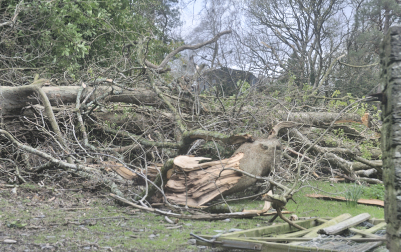
The next image is one that has circulated in the media:
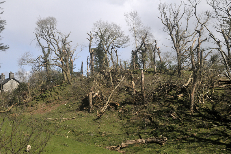
This is looking straight down the tornado track, i.e to the north-east.
At the farmhouse (part of which is in the far left of the image) there was much roof damage. There's a lawn and garden in front of the south-facing gable end in the image. Broken slates and sections of guttering littered this area. So the slates had clearly been lofted from the roof and carried into the circulation. Then they were thrown back down to the ground in the opposite direction to that in which the tornado was travelling. This is exactly as one would expect in a violently spinning column of air: strong evidence for a tornado indeed. But more was to come.
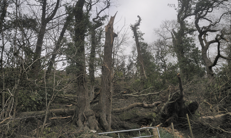
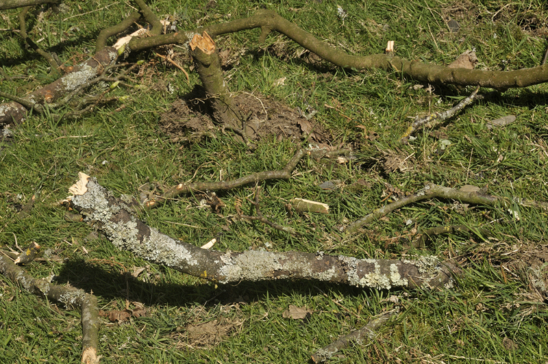
Tornadoes are often described as surgical in the damage they do, meaning that the sides to their paths are very sharply defined, whereas strong straight-line gusts fan out chaotically after hitting the ground. Here's a neat bit of evidence for surgical damage:
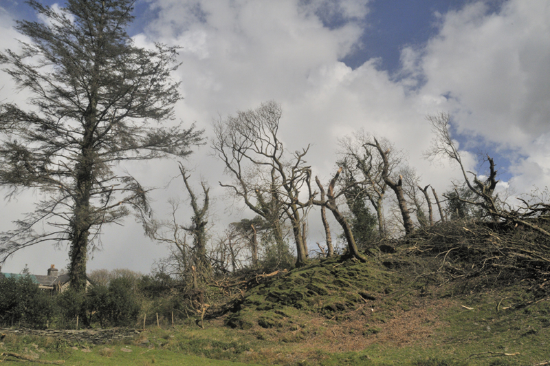
It's a similar, but wider angle view to the previous image, looking down the tornado track, but taken from inside the field. The large softwood tree to the left has some slight damage to branches on its right-hand side. Conversely, to the right - and beginning only metres away, big old - and considerably stronger - hardwood trees have variously been snapped, uprooted and debranched. The RHS of the softwood tree thus marks the edge of the tornado - at this particular point.
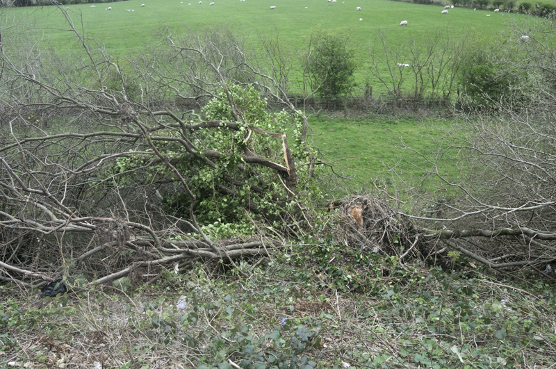
The vast majority of tornadoes in the Northern hemisphere have an anticlockwise spin, just the same as Atlantic depressions. So we look for what we call cyclonic throw of heavy debris. Cyclonic debris-throw will manifest in a SW-NE tornado path as objects thrown to the N or NW, across the path.
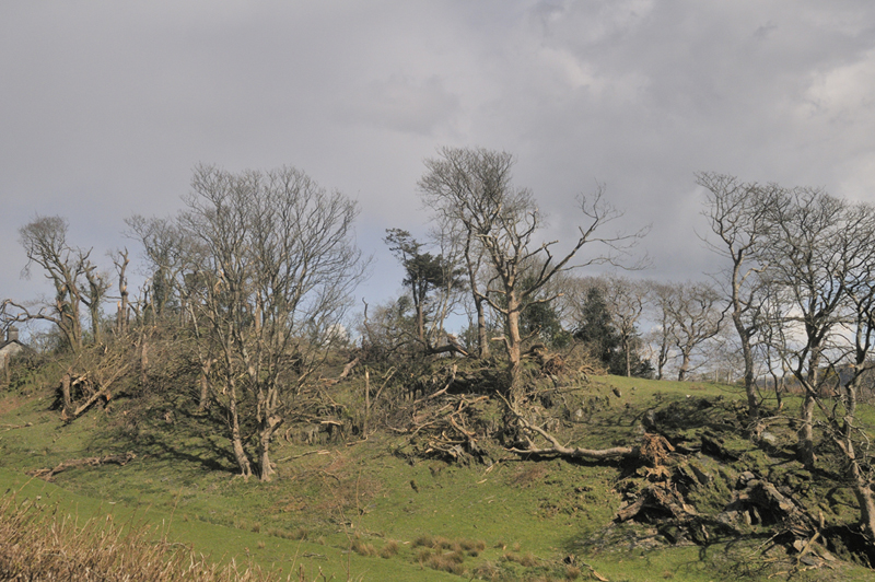
In this image, the big hardwood tree mid-bottom R, with the fresh-looking rootball, had been thrown at an angle to the tornado track, to its north, by the winds in the tornado's leading edge. Cyclonic throw confirmed. Incidentally, the leading edge and southern flank winds tend to be the strongest in most UK tornadoes because they tend to travel in a SW-NE direction so are augmented by that ambient windfield. A 100 mph tornado will thus produce 130 mph winds on its SE flank in a south-westerly windfield of 30 mph speed. That means, as well as cyclonic throw, one finds a lot of objects displaced and thrown in a north-easterly direction, so solid evidence for cyclonic throw is important in distinguishing tornadic and straight-line winds.
There were plenty of other examples of cyclonic throw along the track, but on to the next bit of evidence: embedded projectiles.
Strong tornadoes have little trouble in hurling debris into the ground, which here is sheep-trodden pasture so pretty hard. You see such sights in straight-line wind-damage, where a tree has crashed to the deck and its weight has acted as the driving force. That is different to the image above, which is tens of metres from any tree: two moderately thick (40-50mm) fragments of branch have been driven straight into the turf through their airborne velocity alone. Again, sights like this were visible throughout the track. Uphill, areas of thin turf over bedrock were badly "bruised" or even gouged-out, where larger objects had bounced off them before being blown onwards.
So enough evidence there to say, "tornado" with confidence. But how strong was it? Let's take a look at the relevant criteria on the TORRO scale, which runs from T0 up to T10:
T2: Moderate Tornado. Winds 33-41 m/s (73-92 mph)
Much damage to tiled roofs and chimneys. Ridge tiles missing.
General damage to trees, some big branches twisted or snapped off, small trees uprooted.
That certainly applies to some of the peripheral damage to the farmhouse, which was on the NW flank of the tornado, where winds would be a bit slower.
T3: Strong Tornado. Winds 42-51 m/s (93-114 mph)
House roof timbers considerably exposed. Some of the bigger trees snapped or uprooted.
Heavier debris becomes airborne causing secondary damage breaking windows and impaling softer objects.
Debris carried considerable distances.
That applies to the worst damage to the farmhouse; the projectiles box is also ticked and many bigger trees got snapped or uprooted. Some guttering - heavy duty stuff, not plastic - was reportedly recovered from the fields south of the A493 so carried for a considerable distance, yes.
T4: Severe Tornado. 52-61 m/s (115-136 mph)
Motorcars levitated. Mobile homes airborne / destroyed.
Sheds airborne for considerable distances. Entire roofs removed from some houses.
Roof timbers of stronger brick or stone houses completely exposed. Gable ends torn away.
Numerous trees uprooted or snapped. Traffic Signs folded or twisted.
Some large trees uprooted and carried several yards.
Debris carried up to 2km leaving an obvious trail.
Most of these damage-types did not occur, in part because some of the items were not available to the tornado: however, the fourth type, numerous trees uprooted or snapped, certainly applies to the main damage-swathe.
In balance, I would classify the tornado as high end class T3, possibly T4 at its worst. In the American Enhanced Fujita scale, the damage would be high-end EF-1 to low-end EF-2.
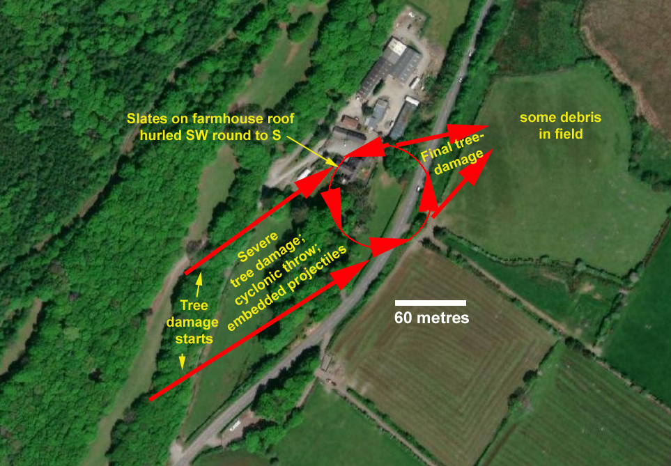
Hee's the final map of the tornado track using an aerial view.
That part of the job done, the next thing was to double-check for any other damage or unusual sights. Social media is useful in this respect and thanks to various helpful people who got in touch, it was possible to establish smaller debris had fallen out over several neighbouring farms up to several hundreds of metres off to the sides of the damage path, for example:
"We had bits of Scots pine almost half mile away, definitely from Gogarth trees we have no such pines so they came from Gogarth and were very small - showed how battered they were" - Eluned Besent, Penmaen Isa.
This is strong evidence for a much wider circulation aloft, i.e. high above the 100 metre-wide path of the tornado on the ground.
How did the tornado form?
I have to thank TORRO meteorologists Nigel Bolton, Matt Clark, Tony Gilbert and David Smart for long and helpful discussion of what can be a complex topic. What we do know is that the tornado occurred at the extreme southern tip of a strong storm-cell embedded in the squall-line, that can be traced back on radar to at least the 0930 BST scan, when it was some 40 km west-southwest of the tornado location and rotating structure (i.e. a misocyclone) was almost certainly present while it was still out at sea.
Misocyclones are defined as areas of rotary air circulation - like a thermal that you see birds of prey enjoying as they do that soaring thing. Thermals are mostly small but misocyclones can be up to 4 kilometres in diameter, the name differentiating them from mesocyclones that are still larger and deeper rotating structures associated with supercells.
As squall-lines on cold fronts or active troughs cross from over the sea to over the land, the increased surface roughness and consequent friction between air and land often enhances both convergence (coming together) and ascent of that air, resulting in low-level intensification of vorticity. Add in a bit of general instability and you have the ingredients for mass-ascent of air and for parts of that ascending air to be rotating.
Tornadogenesis can occur when such a vortex becomes vertically stretched, narrows and spins much faster - just like a spinning figure-skater brings their arms in and speeds up. The fall-out of Scots pine debris, that must have happened soon after it was lofted by the tornado because of the speed at which the system was travelling, suggests in this case that the misocyclone was at least a kilometre across aloft. Within this parent circulation, the tornado itself was able to develop and vortex-stretching through various other interactions that may have included the steep hillside down which the air descended before touchdown, brought it to the ground as a fast-spinning column of air, around 100 metres in width. It is fair to say we don't yet fully understand all the mechanisms for squall-line tornado development.
Such vortex stretching and intensification can occur beneath strong updraughts associated with developing storms embedded within the squall-line. If you have pre-existing miso-vortices along a front then misocyclone and ultimately tornado formation can sometimes occur - but remember, most squall lines do not produce tornadoes, However, if you spot a squall-line on the rainfall radar that has started to separate out into intense areas of rainfall and breaks, look to the areas of intense precipitation close to developing breaks for the strongest risk of severe weather.
Whatever combination of ingredients caused the tornado, the combination did not last very long - by the time the twister crossed the A493, its width had more than halved and it clearly lost touch with the ground shortly thereafter, giving a track length of just a few hundred metres. At the same time, as it moved inland, the squall-line itself rapidly lost intensity. Those observations suggest that the convective instability was greatest over the sea and just inland, before dropping right off. If the air loses its buoyancy, updrafts get choked and without updraughts, there's nothing to sustain a tornado.
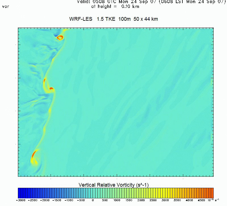
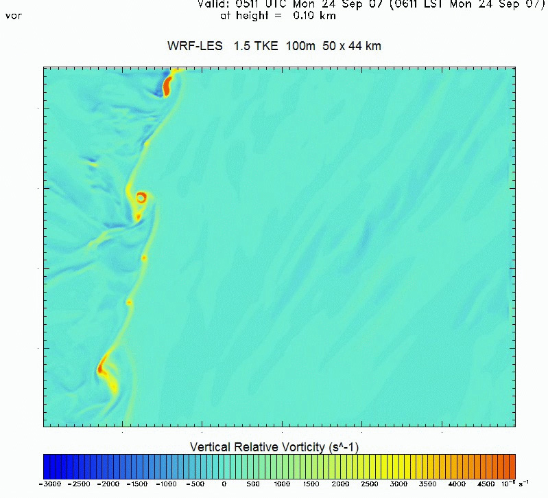
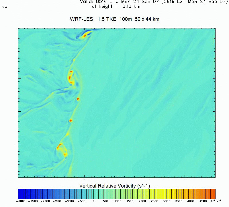
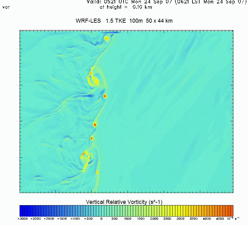
The four images below, stills from an animation, show misocyclone formation and behaviour along a fast-moving tornadic cold front on 24 September 2007. They are taken just minutes apart with the bright reds showing the higest vorticity areas - and you can see how these misocyclones develop, intensify and move along the front through time. Any one of these vortices could turn into a tornado at some point if stretched enough - but because tornadoes are not common, it's clear that exactly the right ingredients are required to create a tornado - and with the right timing. In other words, tornadoes are fickle things that are only well-forecastable in certain environmental situations and then only in general terms!
Thanks to David Smart of TORRO/UCL Hazard Centre for the four images.
Not to be outdone, as April 7th moved into April 8th, a thunderstorm moved in off the sea and afflicted the district south of the Dyfi Estuary with these hailstones, photograhed the following morning:
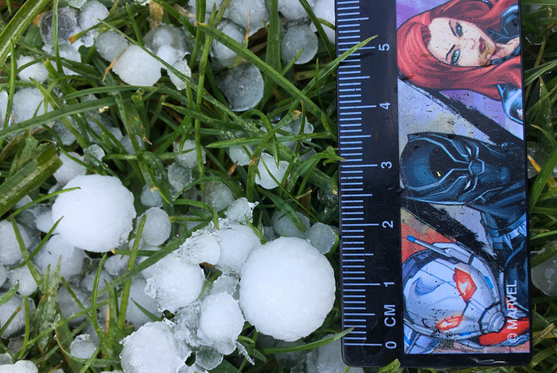
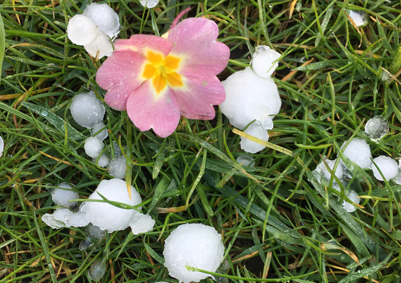
Thanks to Sarah Jenkinson for the images. All happening here; see if I can get this post finished before the forecast thundery showers arrive and I have to power down!
Finally, don't forget I write books when not investigating extreme weather and so here are the useful links:
Wales - The Missing Years and The Making of Ynyslas
are available online (price £9.99 and £7.50
respectively plus p&p) via the following links:
Coch-y-Bonddu Books in Machynlleth:
https://www.anglebooks.com/the-making-of-ynyslas-tales-from-an-area-the-size-of-wales-25-000-years-ago-to-the-present-day-by-john-s-mason-98895.html
Dyfi Osprey Project's new online
shop (they also have Wales - The Missing Years but
not in the online shop just yet):
Museum of Modern Art Cymru,
Machynlleth (likewise, they also have Wales - The
Missing Years but not in the online shop just yet):
https://moma.cymru/en/shop/products/the-making-of-ynyslas/
And at Aberdyfi, community art organisation Artworks
has both:
https://artworksaberdyfi.co.uk/books/mason_john.html
If you are a bookseller and want to
stock either title, then please contact me directly.
Terms offered are identical for all sellers regardless
of size: 35% discount off RRP for wholesale purchase.
For seasonal visitors to the area and locals, Ynyslas
Visitor Centre, Cletwr at Tre'r-ddol and the independent
bookshops in Machynlleth (Literary Cat, Penrallt Books),
Tywyn (Clocktower Books, Talyllyn Railway shop),
Llanidloes (Great Oak Books) and Aberystwyth (Ystwyth
Books, Ceredigion Museum) also have stocks, on top of
the outlets mentioned above.
The Welsh Weather & Dyfi Valley landscapes Image-Library - Click HERE
BACK TO WEATHER-BLOG MENU