BACK
TO WEATHER-BLOG MENU
New!
Fine Art Prints & digital images for sale-
Welsh Weather
& Dyfi Valley landscapes Slide-Library - Click HERE
What does one
do when it's been seemingly raining for several weeks and then the sun
comes out for a ten-day period?? Have a holiday, of course! Now, for me
the likes of Ibiza have little if any appeal - all the stress of
crowded airport lounges, queuing, noise, heat..... the idea of a
holiday is to recharge the batteries is it not?
The
beautiful late September day I describe below certainly did that for
me! Meanwhile the hurricane season is in full swing down in the
Tropical Atlantic, and most years we get some remnants of these storms
heading our way. On October 4th-5th exactly that happened, and a quite
spectacular episode of flooding resulted. More on these tropical
deluges further down the page: first, welcome to Cardiac Hill:
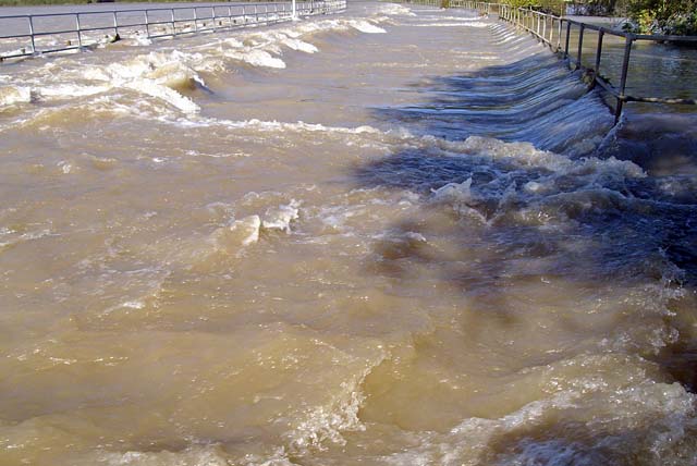
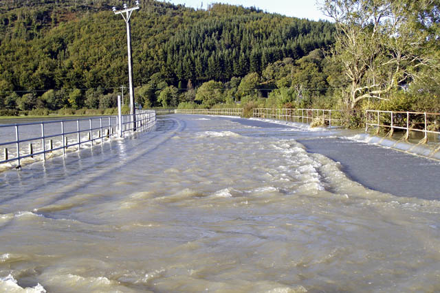
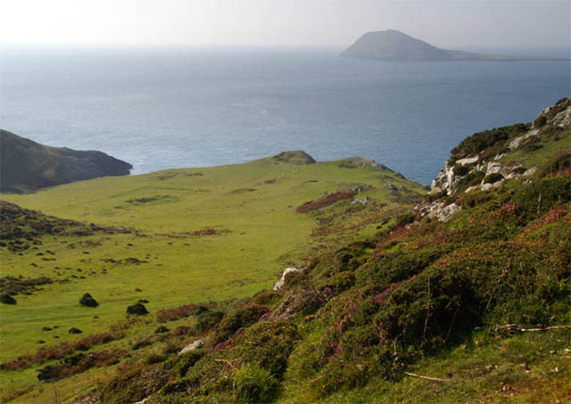 Cardiac Hill is the anglers' nickname for the very south-western tip of the Lleyn Peninsula, beyond Aberdaron and facing the island of Bardsey across the rip-tides of the notorious Sound. Its name comes from the ascent back up when, weary after a good day's fishing, and with the catch adding to the weight of the rucksack, grown men are reduced to staggering along, frequently stopping to lean on their rods and catch breath! This is near its top..... 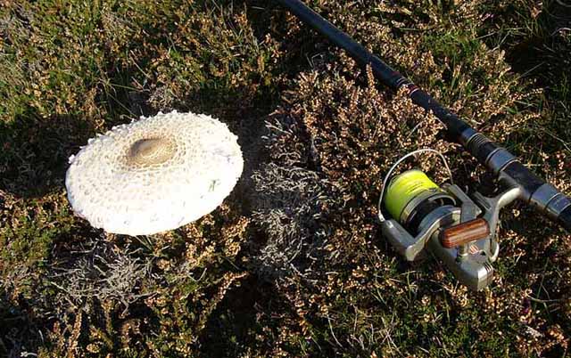 Covered in sheep and rabbit-cropped heather and gorse, it is also a good place for Parasol Mushrooms, which are very tasty when fried with a bit of bacon! 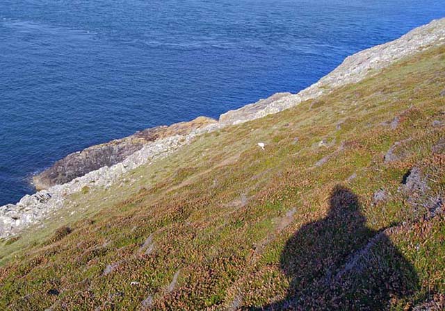 This shot (with the sun behind me) is about halfway down looking towards one of the fishing platforms. Beyond, the disturbance on the sea surface is the powerful tide-rip that occurs here as the tide is ebbing... 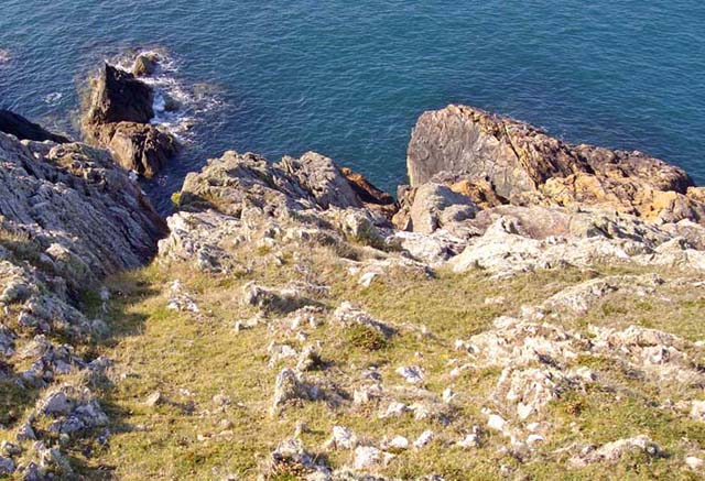 The final 40m of the descent is on steep grass at first before rocky ribs lead down to a steep scramble onto the platform itself. In dry weather this is straightforward with care, but in the wet both grass and rock take on a teflon-like feel: in such conditions I avoid the place out of a preference to stay alive! 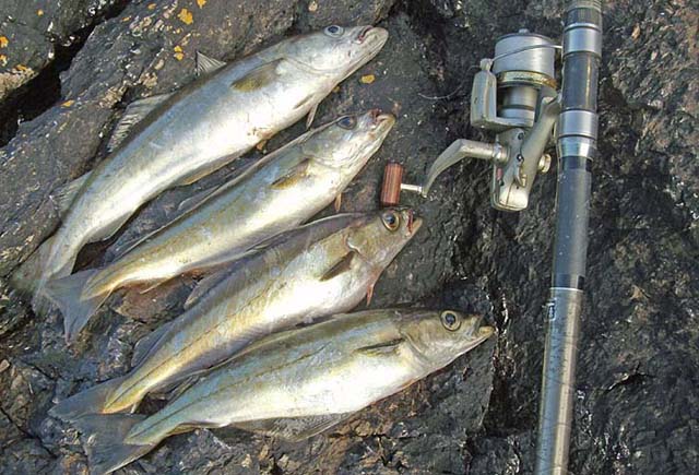 The tide-rip sweeps up small fish around the point and predators lie in wait downtide, charging in and swallowing their prey whole. To catch here, you have to use lures that the fish mistake for such prey. Sometimes there are lots of mackerel here: on this occasion it was pollack that I caught. A member of the cod family, but much fiercer beasts, pollack are good eating provided you clean the catch soon after it is caught. The fillets from these fish are in the freezer awaiting a go on my fish-smoker. 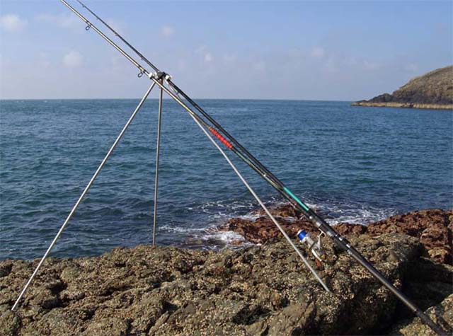 Low tide arrived and the rip died away, so I moved over to St Mary's Well Bay, where you can bait-fish for a range of species, and lazed away a perfect afternoon. Choughs flying overhead in aerobatic groups, all manner of seabirds out there over the waves, seals and quite often dolphins and porpoises - this place is as close to perfection as makes no difference! 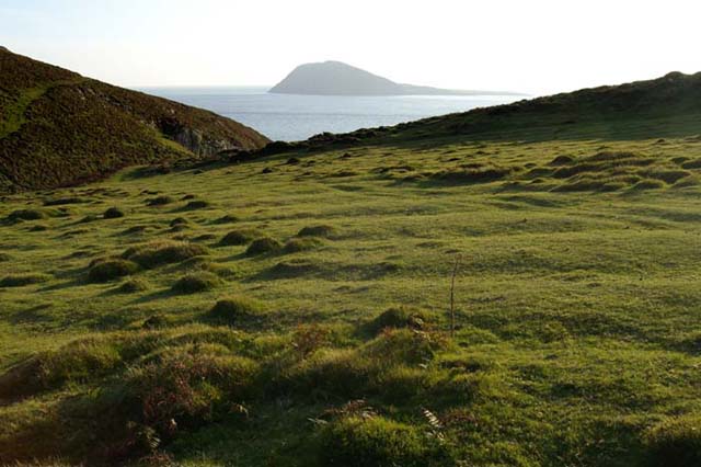 Eventually it was time to head home, so I wandered back up across the ancient field-systems in evening light, to say farewell to Bardsey until the next time. October, and stormy conditions, was just days away. And so to Laura's visit. This was the discussion (they are always in capitals) released by the National Hurricane Center on 28th September - the day after my trip to Cardiac Hill: THUNDERSTORMS ASSOCIATED WITH A LARGE NON-TROPICAL LOW LOCATED OVER THE CENTRAL NORTH ATLANTIC OCEAN ABOUT 700 MILES WEST-SOUTHWEST OF THE WESTERNMOST AZORES ISLANDS ARE SHOWING SOME SIGNS OF ORGANIZATION. THIS SYSTEM IS SLOWLY ACQUIRING TROPICAL CHARACTERISTICS AND HAS THE POTENTIAL TO BECOME A SUBTROPICAL OR TROPICAL CYCLONE OVER THE NEXT COUPLE OF DAYS AS IT MOVES GENERALLY WESTWARD AT 10 TO 15 MPH. This was to become Tropical Storm Laura. Tropical storms are defined as an organized system of strong thunderstorms with a defined circulation and maximum sustained winds of 39 to 73 mph (34-63 knots). Above those windspeeds, you have a hurricane. Tropical storms and hurricanes characteristically have am east to west track, gradually turning north, from their area of origin in the mid Atlantic off the west coast of Africa. This is why they tend to move into the Caribbean and then curve N to hit the southern USA. Sometimes this curve occurs sooner, sometimes later: if sooner then the storm may not make landfall, remaining out at sea, and termed in meteorological slang as a "fish" (nothing to do with Michael Fish incidentally). Laura did exactly that. The final NHC discussion on October 1st was as follows: TROPICAL STORM LAURA DISCUSSION NUMBER 10 NWS TPC/NATIONAL HURRICANE CENTER MIAMI FL AL122008 1100 AM EDT WED OCT 01 2008 ALTHOUGH A SMALL PATCH OF CONVECTION REMAINS...THERE IS NOT ENOUGH DEEP CONVECTION FOR LAURA TO BE CONSIDERED A TROPICAL CYCLONE...AND THIS WILL BE THE LAST ADVISORY. I RATHER LIKE THE CANADIAN HURRICANE CENTER'S TERM POST-TROPICAL...WHICH SIMPLY MEANS NO LONGER TROPICAL...TO DESCRIBE WHAT LAURA HAS BECOME. THERE IS NOT REALLY ENOUGH EVIDENCE OF FRONTAL STRUCTURE YET TO CONSIDER LAURA EXTRATROPICAL IN THE TRADITIONAL SENSE...AND SOME USERS MIGHT INFER A WEAK SYSTEM IF WE USED THE TERM REMNANT LOW...WHICH IS MOST-COMMONLY APPLIED TO DECAYING SYSTEMS IN THE EASTERN PACIFIC BASIN. A QUIKSCAT PASS THIS MORNING SHOWS THAT THE MAXIMUM WINDS REMAIN NEAR 40 KT...PERHAPS EVEN A BIT HIGHER. A TRANSITION TO A FULLY EXTRATROPICAL STRUCTURE IS EXPECTED OVER THE NEXT DAY OR SO...AND THE GFS SUGGESTS SOME REINVIGORATION OF THE EXTRATROPICAL REMNANT OF LAURA IN THREE OR FOUR DAYS. OTHER GLOBAL GUIDANCE...HOWEVER... SHOWS THE CIRCULATION BECOMING ELONGATED AND DISSIPATING WITHIN A FRONTAL ZONE. THE OFFICIAL FORECAST WILL CALL FOR AN EXPANSION OF THE WIND RADII IN GENERAL AGREEMENT WITH THE GFS...BUT FOLLOWS A CONSENSUS OF THE GLOBAL GUIDANCE IN CARRYING A TRACK ONLY OUT TO 72 HOURS. FORECAST POSITIONS AND MAX WINDS INITIAL 01/1500Z 46.5N 46.5W 40 KT...POST-TROPICAL 12HR VT 02/0000Z 48.9N 45.6W 40 KT...EXTRATROPICAL 24HR VT 02/1200Z 52.2N 43.5W 40 KT...EXTRATROPICAL 36HR VT 03/0000Z 55.0N 39.8W 40 KT...EXTRATROPICAL 48HR VT 03/1200Z 56.0N 33.0W 40 KT...EXTRATROPICAL 72HR VT 04/1200Z 56.5N 20.0W 40 KT...EXTRATROPICAL 96HR VT 05/1200Z...ABSORBED This was in reasonable agreement with the forecast track from the day before (below). 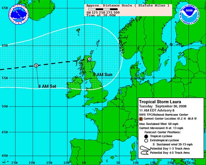 So what does this mean in terms of weather here? Wind, maybe, but in particular moisture - and lots of it! What typically happens is that such tropical systems run into the conveyor of Atlantic depressions that move west-east across the ocean before arriving here in the UK bringing the wet and windy weather we often have. They become entrained into such systems and are finally absorbed by them, but because of their tropical origin, where warm seas allow for lots of evaporation of water into warm air that can carry more moisture than cold air, they bring stacks of that moisture with them. In turn, upon meeting the hills of the western UK, the warm moist air cools rapidly and dumps its payload of moisture as prolonged torrential rain. A damp to wet Saturday 4th went downhill in the evening as prolonged heavy, squally rain set in and lasted the night. Warnings had been issued for 50-100mm of rain over the Welsh mountains - that's two to four inches - a lot for one night. The rain cleared to beautiful blue skies by mid-morning on Sunday 5th so I set out to record the flooding that I knew would have happened.... 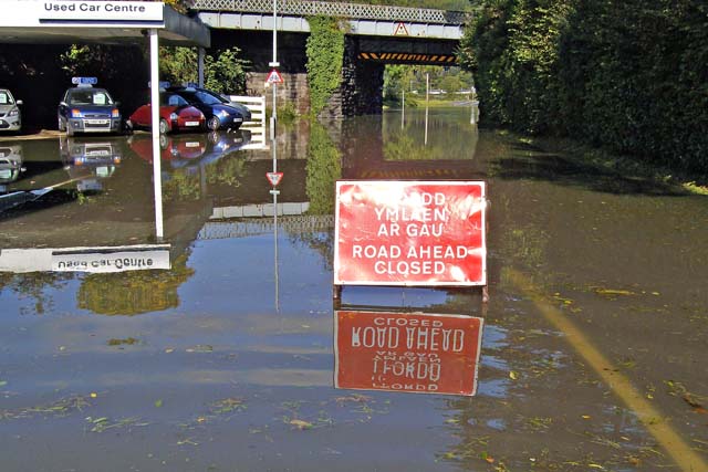 What I met with was a flood on quite a big scale - as bad as anything I have seen in the valley. Here is the forecourt of Station Garage and the railway bridge over the A487 that heads out to Dyfi Bridge, half a mile from here. There is a dip in the road under the bridge, to allow lorries to pass under, and in this image there would have been getting on for a metre of water under there. Drivers of lorries, vans and 4x4s get caught out here regularly, taking an optimistic run at the water and conking out, sometimes (with diesel engines) with major push-rod damage if their air-intake has pulled water into the cylinders. Every time this spot floods, there are several cases of "bent engines". The moral is - if it says "Road Closed" it means just that!! 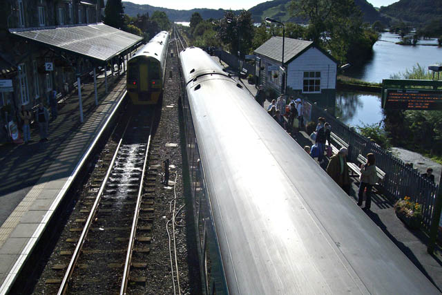 Some rail disruption was also occurring with people waiting for buses for the next stage of their journey. The water-filled valley is visible R. 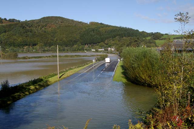 Here is the view from the end of the platform, looking out over the A487. This dryer section after the bridge is deceptive as just afterwards one gets to "the rapids"..... 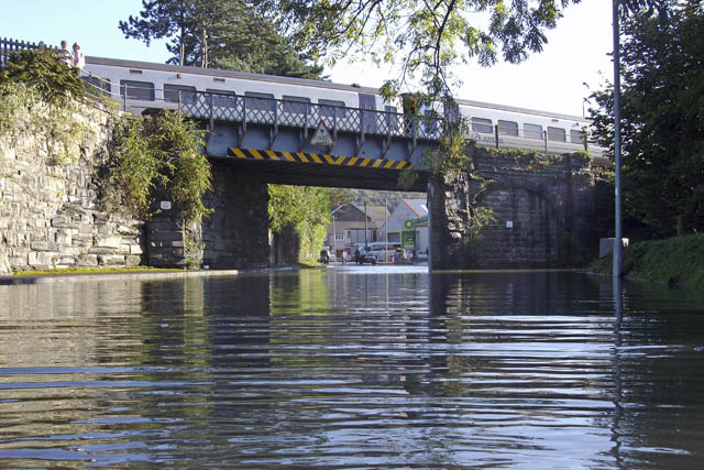 I walked down from the station to the other side of the railway bridge and out to the rapids.... |
|
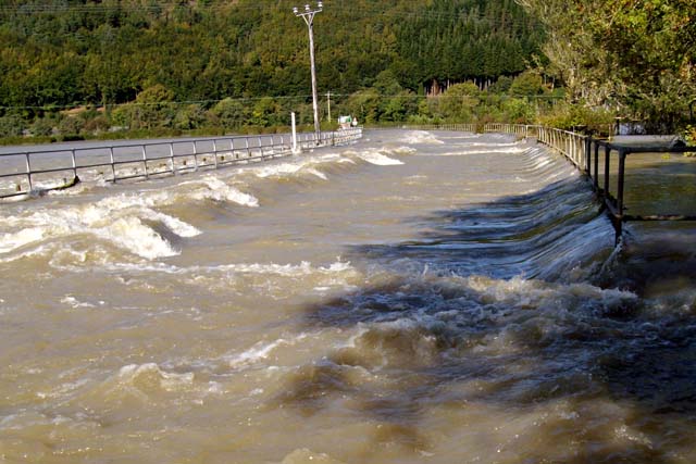 Here, the full force of the water running along the flood-plain is met with. The shallower bit here is incredibly swift-flowing. You would have a job to wade it even though it's only a foot deep at best. People have been swept away here before..... |
|
 ....but with care it is possible to get some interesting shots... 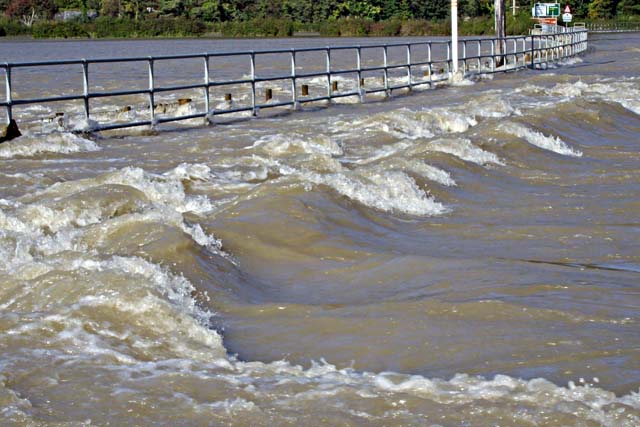 ...with the detail in the way the water flows a prime focus for the lens.... |
|
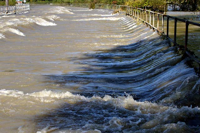 The above four images were taken at about 1300 - at the time high tide was occurring 10 miles away at the river's mouth. The tide ponds the water in, even though it was only a small neap this time..... |
|
 |
|
| This was taken three
hours later, with the outgoing tide letting water-levels drop quickly.
It was now possible to wade the rapids, but even then the water was
powerful enough to be felt. Rainfall totals look to have been well into the upper part of the forecasted 50-100mm*, so this was a good call by the Met Office and other forecasting agencies. Well done to them! This morning (6th October), the charts for the coming weekend hint at a chance of some kinder weather, warmth and sunshine. Let us hope so, before too much dust has gathered on my fishing rods! * Roger McLennan of the Centre for Alternative Technology, 3 miles NNE of Machynlleth, maintains a rain-gauge there and he has recently reported to me that the event produced 92mm of rain. Thanks, Roger! |
|
BACK TO WEATHER-BLOG MENU New! Fine Art Prints & digital images for sale- Welsh Weather & Dyfi Valley landscapes Slide-Library - Click HERE |