Spring Convection over the Welsh
mountains - 18th May 2003 - a storm photography dream!
BACK TO WEATHER-BLOG MENU
New! Fine Art Prints & digital
images for sale-
Welsh Weather & Dyfi Valley landscapes Slide-Library
- Click HERE
The day started
off in a rather average way - little did I know how it
would end! Instability was present in the SW round to NW
airflow and on looking at the Met Office radar and on
seeing some storms leaving Eire and heading vaguely this
way across Cardigan Bay I made my way to the coast
between Aberdyfi and Tywyn, arriving at about 11am.
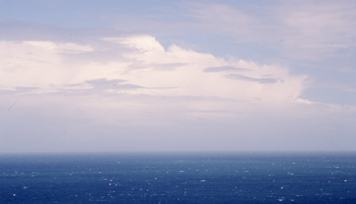
Out to sea some powerful cumulonimbus cells were dotted about, but they were on a more northeasterly course - heading for the Isle of Man at this rate! A windy day with a force 5-6 blowing steadily and disturbing the sea surface. Went home, did other stuff and periodically checked the satellite and radar. An interesting and persistent feature had run up across S Eire from the Atlantic and was now setting off towards Wales. Rainfall radar and sferics indicated strong precipitation and periodic electrification. ETA here was estimated at 17.30pm BST....
I arrived back at the coast to see a few weak convective cloud-towers going up (and falling down again!!), with the feature of interest still in the distance....

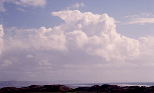
At about 6pm it was approaching steadily and appeared quite substantial, if a bit unphotogenic apart from this cirrus-like streaky cloud slanting upwards and outwards towards land. The rain arrived and I drove back to Machynlleth through occasionally heavy bursts and nothing much to see. After an hour or so I noticed a strange, purple tint to the sky to the S and just after 7pm I set off for a third time, this time towards Dylife on the Machynlleth-Llanidloes mountain road.
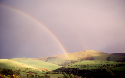
I soon went straight into torrential rain and hail with the radio crackling like mad (indicating nearby lightning discharges), so I did an about turn and got out of the precipitation and waited. I could see that the feature was clearing with blue skies on the way. A bit of rainbow-pic indulgence followed, but by now the underside of the anvil was starting to light up and the presence of mammatus clouds was being hinted at.......

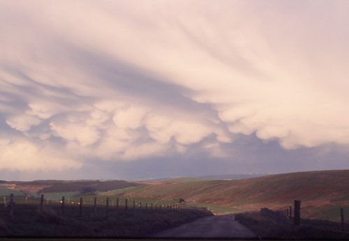
I thought this was impressive but I hadn't yet seen the sight that was shortly to present itself to me. As the sunlight filtered through more and more mammatus clouds started to show themselves. I went quickly up to the top of the pass (really was chasing at this point!) and down the other side a way to where I knew there was a safe parking place with an extensive view N, E and S...
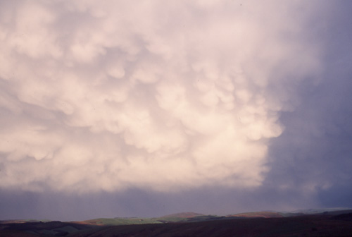
As the sunlight worked its way along the gloom was drawn back, like a curtain being opened.
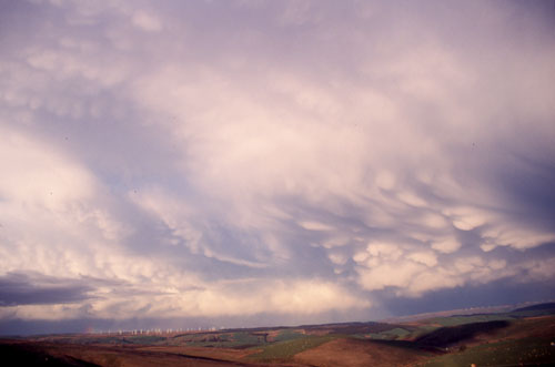
Mammatus clouds are basically pillowlike pockets of cold air sinking down from the underside of a thunderstorm anvil. They may indicate a severe thunderstorm but can occur with even small cumulonimbus shower-clouds. However, the scenes illustrated here show a scale of development indicative of organised, marginally severe storms - the sort capable of producing sizeable hail and gusty winds....I was loving every minute of it!
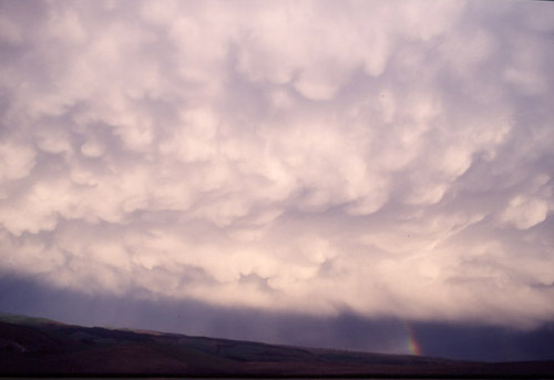
This is looking N, about 7.40pm
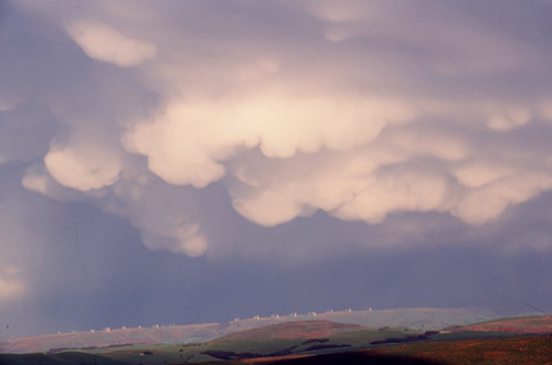
This is looking east through the telephoto lens towards the LHS of a second cumulonimbus over the windfarm on Trannon...
This is the southerly cumulonimbus, this time panned round to the SE with Llandinam windfarm in the distance...
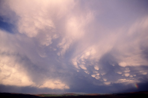
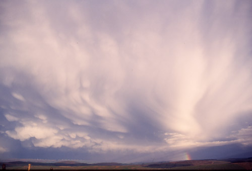
Wide-angle a little later, looking east with the northerly and southerly storms side-by side. The way that this thing kept evolving was incredible and amazingly a beautiful little rainbow appeared (R)!
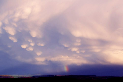
The rainbow invited some more telephoto work (despite the difficulty in handholding the camera in the blustery chill wind: in this one shafts of hail can be seen falling just L of it....

In this one bright crepuscular rays (sun lighting up particles in the air) beam out from the rainbow!
Here are both storm-cells again, now starting to get a bit further away...
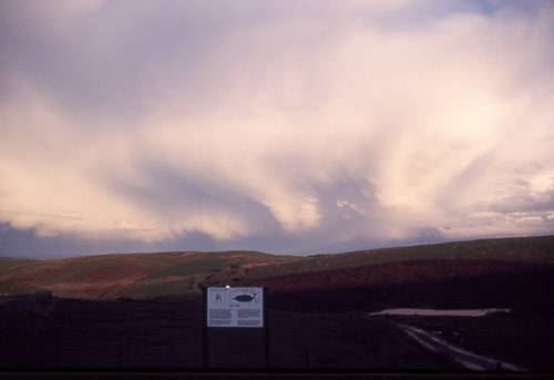
As it did so the incredible twist to the base of the anvil became more apparent. What appears to be going on here is the effect of wind-shear, in which, at different altitudes, there are differing wind-directions. Because convective storm-clouds go up vertically, they may encounter such wind-changes at different heights. One effect this can have is to separate the updraught and downdraught in a storm-cell, which is a thunderstorm's version of sustainable development, because it allows convection to continue unchecked, thus prolonging a storm's life and often increasing its severity.....
And as the light faded the storms headed off over the horizon and an evening chill descended over the damp valleys. The wind dropped and all fell silent. I turned and headed in the opposite direction, to the west, getting down to Machynlleth at about 8.30 where a well-earned pint or three were had!
This particular feature was electrified and persisted from the E Atlantic across Eire, the Irish Sea (where for a change it didn't weaken too much!), Wales (where it intensified as it came up over the Cambrian Mountains) and England, where it was giving sferics after dark in the Midlands. 12mm hail was reported in Worcester from the same multicellular complex of storms but the heaviest radar-indicated precipitation was across E Wales into Shropshire. Any accounts from Sunday Evening, May 18th, would be gratefully received - see my email link on the menu page.
The lesson from today was
that persistence pays off. Something any would-be
stormchaser has to learn and learn fast. Two hours like
the last two on May 18th 2003 more than made up for many
more unfruitful ones in the past! Another
lesson is to have plenty of film spare: this selection
was made from two 36-exposure slide films that I used up
recording this extraordinary moment of beauty.
BACK TO
WEATHER-BLOG MENU
New! Fine Art Prints & digital
images for sale-
Welsh Weather & Dyfi Valley landscapes Slide-Library
- Click HERE