SPRING
2007- part 1: March 18th - Convective storm spectacular!
BACK TO WEATHER-BLOG MENU
New! Fine Art Prints & digital
images for sale-
Welsh Weather & Dyfi Valley landscapes Slide-Library
- Click HERE
It's been a while again since I
updated the site! Too much work and not enough storms!
March is typically an awkward month for
storm-photography. Sea temperatures are pretty much at
their coolest, so that it takes very cold air to move in
over the sea for convection to fire: the other side of
the coin is that inland, solar heating starts to have an
effect, so that "home-grown" storm-cells,
albeit fairly weak, are able to develop. Two dates did
provide something worthy of attention: firstly an
afternoon during which distant fallstreaks provided a
couple of tidy shots from Borth....
 |
|
 ....and, more significantly: Sunday March 18th did break with the trend, and gave an excellent potential opportunity for the camera. Here's a snippet of forecast discussion from the UK Weatherworld forum (highly recommended to anyone with more than a passing interest in all things weather): "Synopses show a number of very active surface troughs moving in across Ireland and the UK throughout the day. Upper cold pooling is synonymous with expected lapse rates near coastal regions likely to soar! In fact this gives for a VERY unstable atmosphere which will likely show numerous convective thundersnow showers to most coastal regions for UK and Eire through Sun and Mon. Prime convection will utilise milder sea temps and thus favour west facing coastal regions through the said period." Although there were the usual waverings in the model output, the day still looked good, so it was definitely a case of heading to the coast in the chilly winds and sitting it out to see what would turn up. Tywyn was first port of call, followed by the high coastal vantage point near Llwyngwiril. I think the results justified the effort! |
|
 Upon arrival at the coastal vantage-point, and in the first showers trundled - tight little cores of small hail and a bit of sleety snow - nothing very exciting as yet... |
|
 Because they were dropping hail/snow, they looked heavier than they actually were! Periodically, bright sunlight dappled the water, which was fairly murky following the strong winds that tend to stir up sediment on the sea-bed... |
|
 The first bunch of showers decayed as they approached leaving swirls of remnant precipitation, but with more visible beyond - perhaps the next lot would deliver the goods? |
|
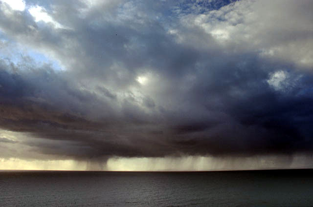
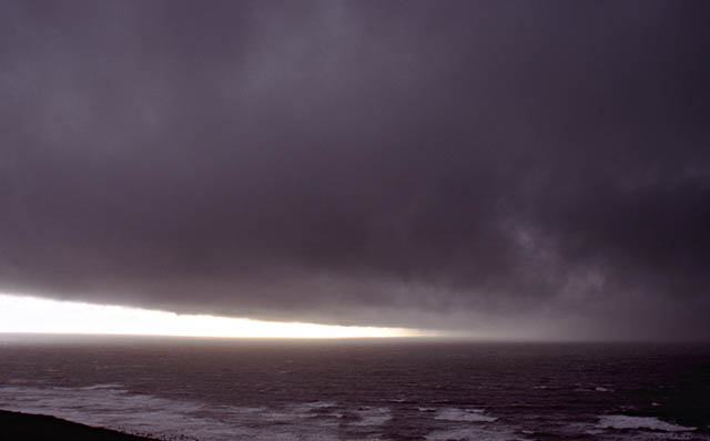
 As luck would have it, an intense cell could now be seen upwind (out of view R), clipping the Lleyn Peninsula, whist dark scud bowled along overhead in the NW-erly near-gale. I decided to await its arrival, figuring its SW edge would just about clip me so that I would get a reasonable view of any interesting developments right up to the last minute.... |
|
 ...as it moved closer a gust-front started to develop around its forward flanks, whilst beyond, the darkness suggested heavy snow and hail was falling (as indeed had been forecast). The lighting was good as the late afternoon low-angle sunlight was filtering in from the L.... |
|
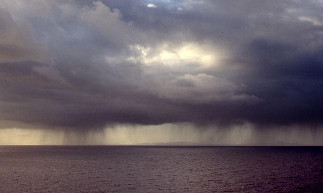
 ...providing a stark contrast between the gust-front and the darkness beyond... |
|
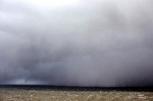
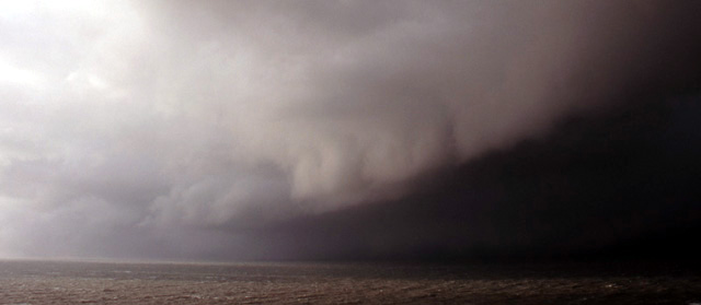 ...very close now, with sunlight partly illuminating the sea, and hail could be seen falling only a sort distance to my north. I made a pass northwards under the gust-front, complete with a "whale's mouth" structure which I didn't bother with as the view also included rooftops and overhead lines! In Llwyngwiril, hail fell in torrents, rattling on the jeep roof and spinning along the street in squalls, and I turned around to get back to the vantage-point.... |
|
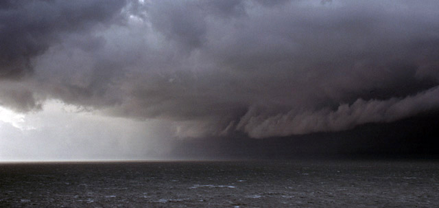
 ...to find myself beneath this incredible, very low and extensive anvil. Convective storms in winter often exhibit very low anvils and are often referred to as "low-topped" storms. Another core of precip was visible out to sea, but the main storm was passing, and sunset was slowly approaching.... |
|
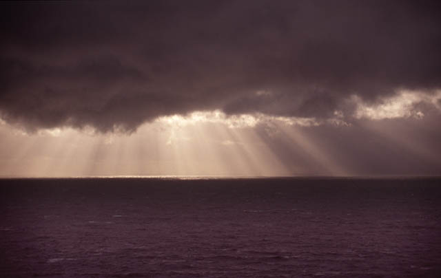 Shortly, the remains of the clump of storm-cells was to pass away over the hills inland, with the setting sun providing some nice optical efferts.... |
|
 ...before dipping below the visible horizon, leaving raggedy cumulonimbus clouds to form a darkening backdrop. Further showers fell as snow overnight, but amounts were largely small. As high pressure grew over the UK into April, with attendant climbing temperatures, the camera stayed in the bag largely... |
|
 ...as the haze prevented a decent look at most things. I liked this view, with the outlines in differing greys, from the New Precipice Walk near Dolgellau, looking SW towards the foothills of Cadair Idris, with the mountain itself in the background. On some days the haze has left visibility down to only a mile or two. Occasional slack low-pressure incursions have created small amounts of instability inland and I did manage to chase what turned into one of two thunderstorms over Wales a few days ago, but in terms of rain that has pretty much been that! |
|
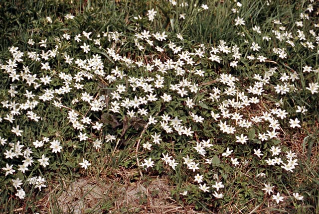 Luckily the ground-moisture has balanced out the lack of rain up until now (April 20th) to a great extent, allowing an excellent display of spring hedgrow flowers - not something I am much good at photographing but I couldn't resist a shot of these wood anenomes about a week ago! Will May bring anything different, or will dry, sunny and unexciting for the forseeable future? Time will tell! |
|
BACK TO WEATHER-BLOG MENU New! Fine Art Prints & digital images for sale- Welsh Weather & Dyfi Valley landscapes Slide-Library - Click HERE |