Winter
2004-05 PART 2:
The Atlantic awakes - and brings tornadoes and
landslides!
BACK TO WEATHER-BLOG MENU
New! Fine Art Prints & digital
images for sale-
Welsh Weather & Dyfi Valley landscapes Slide-Library
- Click HERE
On the evening of December 27th an
active cold front passed over England and Wales, with
embedded thunderstorms. Such features are known as
squall-lines and they can produce extremely violent
weather, although they tend to be narrow and pass through
quickly. Here are the notes I hastily wrote that evening:
"At about 9.55pm this evening I
was enjoying a glass of wine and watching a DVD when
suddenly the power went off, then came on again within a
few seconds. Shortly after there was a rattle of hail at
the window and then all hell broke loose. I rushed to the
front door and watched as sheets of torrential rain came
swirling horizontally up the street (i.e. in a N to S
direction), playing on the walls of the buildings
opposite as if being fired from a hosepipe. At times the
rain was actually moving diagonally upwards. Above the
howling of the wind and rain was a second distinct sound
- a deep roaring that passed in the darkness, seemingly
up the valley below me (I live on a slight hill just
above the flood-plain of the E-W trending Dyfi Valley).
Within only a couple of minutes an inch of water was
running down the street. I then noticed several
neighbours on their doorsteps looking out into the night
and asking what on earth had passed through and made that
roaring. The rain continued, but less heavily, for a few
more minutes while winds remained squally but not with
the violence of that first assault. Thereafter things
quietened down to how they had been prior to the power
cut."
The following morning I set off across the fields towards
the Dyfi looking for one thing - tornado damage. That
deep roaring is a sound often reported with tornadoes, so
I was somewhat disappointed to find no trace of damage at
all! However, elsewhere in Wales this was not the case
and a day or two later I investigated a tornado damage
track near Trefenter, south of Aberystwyth in the rolling
hills of mid-Ceredigion.......
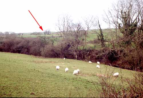 The Trefenter event took place close to 10pm on the night of the 27th and was accompanied with that same terrifying deep roar, "like Concorde taking off". There the similarity ended. This was a tornado that caused damage. The above image is looking back along the damage track from the small farm it hit. The arrow points to where it carved its narrow (10m wide) path of destruction through the small wooded valley ..... |
|
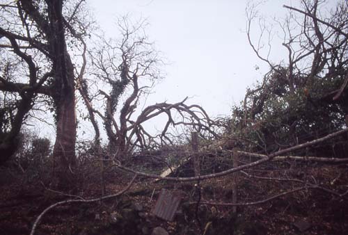 ....and this is within its path. Multiple tree-damage with branches and crowns snapped off. Tornadoes often cause a lot of snap-off damage. Most of the branches were thrown NE from the parent trees: given that the prevailing wind that night was WNW-ESE and most tornadoes have anticlockwise circulation this is consistent with the strongest tornadic winds, on its SE flank, where they blow SW-NE. |
|
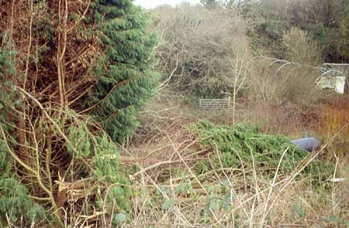 At the top of the field the tornado struck a windbreak of sturdy Leylandii conifers and snapped them off close to ground-level, again throwing them slightly NE. The largest affected tree had a trunk 25cm in thickness. Leylandii are notoriously strong - these were growing squarely in the path of the prevailing wind - and the force to do this takes some imagining! Also note in this image the polytunnel and greenhouse in the background - utterly unscathed. They were not in the tornado's path but some distance to its north - fortunately. |
|
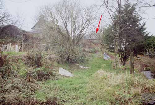 The tornado then removed the ridge-tiles and the steel chimney-flue from the barn in the background (arrowed). This image is taken in the area where the couple living here picked up most of the tiles, mainly broken! Very fortunately the tornado missed the farmhouse itself. |
|
 This is a close-up of the objects lying in the foreground of the above image! Prior to the tornado's arrival, this 1 x 1.5m piece of 10mm ply was the other side of the barn. It had travelled up over the barn and cast down, snapped clean in two, on this side! I tried to break the larger piece and could only bend it slightly! Beyond that there was no more damage, indicating that the tornado had lifted after hitting the top of the barn, but bits of roof insulation and Leylandii foliage were lying about on the ground for a little further. Rating-wise this was in the upper end of T2 on the TORRO scale: T2 - Moderate Tornado: wind 33 - 41 metres/second or 73 - 92 mph. Heavy mobile homes displaced, light caravans blown over, garden sheds destroyed, garage roofs torn away, much damage to tiled roofs and chimney stacks. General damage to trees, some big branches twisted or snapped off, small trees uprooted. This was one of several tornadoes from that cold front. Others were confirmed after TORRO site investigations in South Wales, Somerset and Gloucestershire, making this a significant tornado outbreak by UK standards. And only days later a second active cold front brought with it another outbreak, on January 1st 2005: a grim start indeed to the new year for some. Here, meanwhile, the next lot of weather-related trouble came on the 7th..... |
|
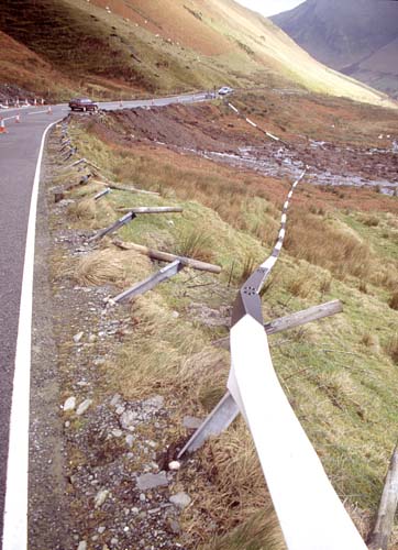 A rapidly deepening Atlantic depression tacked across the UK bringing a swathe of storm-force winds and prolonged heavy rain on the 7th and overnight into the 8th. By the following morning things had calmed down and I went out for a look. Firstly the Dyfi - as it tends to in such conditions - had burst its banks and the main road north out of Machynlleth was closed. As often happens several times each winter, some drivers had attempted to drive through the deep floodwater and had run into trouble. The Dyfi Bridge section of the A487 is a graveyard for diesel engines wrecked when water gets sucked up into the air intake - beware! What was of interest was the landslide that affected the A470 just below the top of the pass between Dinas Mawddwy and Dolgellau. This was a classic bog-burst type, when an intense rainwater buildup occurs under a peaty bed of reeds, sphagnum moss etc, sat upon an impermeable glacial drift subsoil. This pushes the peat and vegetation up until the consequent "dome" ruptures. It shot ca. 80m down the steep hillside, with a track 15m wide at the top, widening to 25m at the road and fanning over a broad area in the valley below. 80m of steel crash-barrier was torn from its mountings, though still in one length, and as seen here it lay in a big arc across the debris well below the road..... |
|
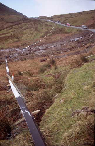 ....here looking up
in the opposite direction.... ....here looking up
in the opposite direction.... |
|
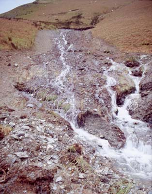 .....and here looking straight up at the slide along its path.... |
|
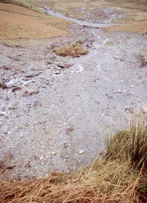 ....and here looking down from its point of initiation. The road only suffered minor damage as most of the debris was peat and vegetation, but boulders weighing upwards of 75kg were also transported. Clearly a forceful debris-surge that would have had very serious consequences if any traffic had been passing as the A470 can be a very busy trunk-road. |
|
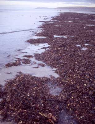 The storm also had its consequences at sea. Here, days later, a vast raft of torn-up seaweed lies near the low water mark at Borth beach. In amongst it were bivalves torn from the seabed and quite a few dead fish - mainly whiting, gobies, flatfish and wrasse, plus a solitary (and very dead) small octopus. Big storm-seas are lethal for anything unwise enough not to get out of the shallows.... |
|
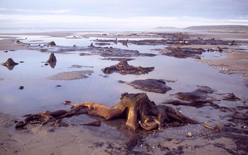 The same seas had also scoured much sand from the beach, revealing Borth's famous "fossil forest". These are the remains of pines and birches, in a bed of peat lying on grey clay. The "forest" is believed to have flourished about 6000 years ago, when sea levels were lower - in fact, since the ending of the last ice-age, 11500 years ago, it is estimated that sea level off the Welsh coast have risen by as much as 90m! |
|
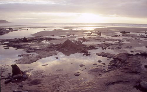 Sobering stuff, given the way that the arctic seems once again to be in a melting-dominated phase of its climate, but that aside the "forest" is a peaceful and photogenic spot on a calm midwinters' afternoon. The Atlantic had gone back to sleep.... |
|
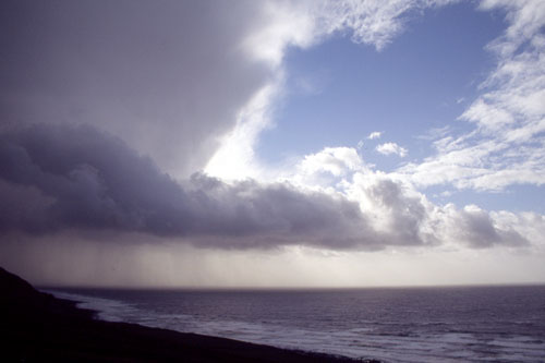 ...and so it dozed through January, with cool rather gloomy anticyclonic weather dominating. The middle of February finally brought a change in the shape of a Northerly blast and convective wintry showers, and the first storm-chase of the year! As I write we're a day or two away from the coldest period of winter weather for a long time. Enjoy! |
|
BACK TO WEATHER-BLOG MENU New! Fine Art Prints & digital images for sale- Welsh Weather & Dyfi Valley landscapes Slide-Library - Click HERE |